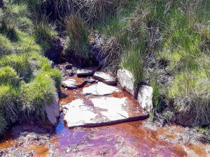
This text deals specifically with that part of the River Exe that flows through Exmoor. The river begins its journey at Exe Head at an elevation of 458 metres. It flows in a easterly direction through the mires of Exe Plain to Exe Head Bridge which carries the B3223, the Lynmouth to Simonsbath Road. Continuing in a easterly direction it flows through Prayway Meads in the moorland valley between Great Buscombe to the North and Little Ashcombe to the south before flowing beneath Warren Bridge, a single arch stone bridge. Flowing on through the fern clad hills of Exe Cleave, and after receiving water from Rams Combe and Sparcombe Water the river reaches Westermill Farm, and soon after flows beneath Silly Bridge to reach Riscombe where it turns to a south easterly direction to meet with Allcombe Water and Greenland Water. These two waters flow down Swincombe Cleve from origins on Wellshead Allotment. The river continues on past Edgcott, where Edgcott Water joins before reaching Exford. From source to Exford the river has travelled close to twelve kilometres with an elevation drop of 200 metres.
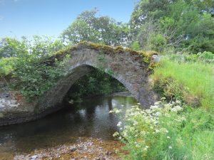
At Exford it flows beneath Exford Bridge, a listed three arch structure and continues past Southcott and through the pastures on the edge of Lyncombe Wood to reach Lyncombe farm where it flows beneath a splendid 17th century single arch humpbacked packhorse bridge which once carried a now abandoned track over Staddon Hill. From Lyncombe the river takes a southerly course and flows to the west of Lyncombe Hill through Curr Cleave to reach Nethercote and continues on below Bye Common to Larcombe Foot where it receives the waters of Larcombe Brook which flow down from origins on Staddon Hill. The river then flows through the valley at the foot of Bye Hill and after a journey of close to 21 kilometres it arrives in Winsford.
At Winsford it receives the waters from Winn Brook and flows beneath three bridges, the first being a medieval two arch packhorse bridge restored in 1952, the second is Vicarage Bridge, a three-arched road bridge built in 1835 for the turnpike, which was strengthened and widened in 1928. The third bridge was built in 1952 on the site of an old arch bridge destroyed in the 1952 floods. To the south of Winsford the river flows beneath Edbrooke Bridge, an ancient two arched packhorse bridge rebuilt in the 18th century, it once carried the road to Winsford until the new turnpike road was made in 1824. From Edbrooke the river flows through a wooded valley which runs between West Howe Hill and Edbrooke Hill to reach Coppleham where it flows beneath Week Bridge, a single arch reinforced concrete bridge, built in 1927 and designed by Edward Stead. Just a short distance past Week Bridge the waters of the river Quarme which originate on Hoar Moor join the flow.
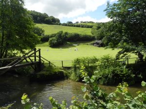
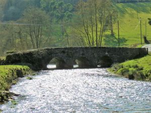
Continuing a southerly direction the river flows to the west of Exton where there is an 19th century weir and leat that powered the waterwheel of Bridgetown corn mill, the grounds of which are now used as a campsite. Passing beneath Bridgetown Bridge the river flows past Bridgetown cricket green to reach Milton’s Bridge. The river continues between Broford and Howe Woods where waters that originate near Stolford Hill Cross join, and continues on past Winslade Wood to Kent’s Weir which provided power via a leat to Kents Mill constructed in the 19th century. Flowing beneath the humpback Chilly Bridge the river continues through wooded valleys and passes close to the remains of Barlynch Priory, founded c.1175 and dissolved c.1537. After travelling close to 34 kilometres the river arrives at the medieval three arched Hele Bridge.
Just beyond Hele bridge a weir provided power via a leat to Weir Saw Mill and after passing beneath Weir bridge the river is joined by the waters of the River Haddeo and then by the waters of the River Barle before reaching Exebridge. The Rivers journey from source to Exebridge is approximately 37 kilometres with a fall in elevation of close to 340 metres.
Source: 457.9 m or 1502.4 feet – Location :51.15831,-3.78638
Click the button below to watch a playlist of videos showing the river’s journey from source to confluence with the River Barle. A gallery of the individual playlist videos is also shown.
Image Gallery Location Map Structures Sounds of the River Exe