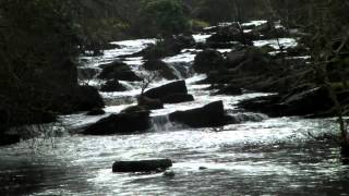
Chalk Water rises in Madacombe and flows north for approximately 3 miles to join Oare Water at Oareford.
From it source it flows east of Kittuck Meads to reach Three Combes Foot where it is joined by waters from the western side of Kittuck Meads and waters from Hoscombe. It flows on through Kittuck Barrow where it is joined from the west by a stream that flows through Stowford Bottom, and later, waters from Outer Alscot Combe and Inner Alscot Combe join from the east and waters from Oldhay Combe and Blindwell Combe join from the west. Its journey is complete when it meets Weir Water at Oareford Bridge to form Oare Water. From source to its confluence with Weir Water there is an elevation fall of close to 145 metres.
Source: Elevation 417.5 m or 1369.8 feet – Location :51.17164,-3.67074
The River Batherm rises south of Clatworthy Reservoir in Home Wood near the village of Sperry Barton.
During its early journey it is joined by numerous streams that include those from East Hays Plantation, waters that rise near Heydon Hill, and streams that flow past Raddington Bottom and Clayhanger. These combined waters flow on past Haynemoor Wood to reach Shillingford where the river flows beneath the B3227. The river follows the B3227 before flowing back beneath at Hukely Bridge to reach Bampton. From Bampton it flows on to reach the A396 near Exmoor Inn and a short distance after it reaches its confluence with the River Exe.
The river meanders for much of its journey – the distance “as the crow flies” from source to its Exe confluence is 7 miles but the meandering distance is 11.5 miles with a fall in elevation of close to 110 metres.
Source: Elevation 321.8 m or 1055.6 feet – Location :51.06605,-3.40779
Bampton Bridge
Video Gallery
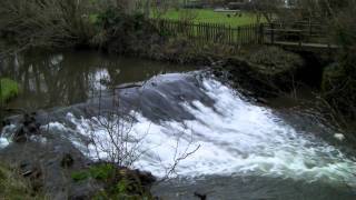
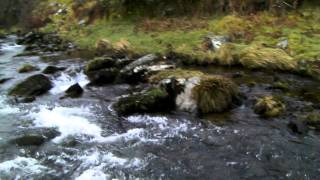
Shillingford Bridge Weir - River Batherm
View More
The Barle rises on the Chains – the north west plateau of Exmoor – at a height of 1450 feet above sea level. Around 1830 the Knight family created, for unknown reasons, a reservoir from the headwaters of the Barle – Pinkery or Pinkworthy pond.
Pinkery or Pinkworthy pond.
From the reservoir the Barle flows south to Goat Hill bridge before taking a more easterly direction and flows through a beautiful moorland valley, where it takes waters from Great Vintcombe, Little Vintcombe and Smallacombe. It flows beneath Ricksy Ball to Cornham Ford and on past Drybridge Combe and through Cornham Brake where the waters of Bale Water join. After a distance of approximately 8.5 kilometres it reaches Simonsbath. The fall between source and Simonsbath is approximately 415 feet. At Simonsbath the waters of the Barle provide the power for a historic saw mill.
Simonsbath Bridge
Flowing beneath the medieval Simonsbath bridge, a Grade II listed structure, the river is joined by Ashcombe Water and waters from Halscombe and Little Halscombe. It passes Flexbarrow to reach the site of Wheal Eliza, the ruins of a copper mine which closed in 1854. A little after, the waters of Great Woolcombe join the Barle and it continues on past Cow Castle, an iron age hill fort, where the waters of White Water join. At Sherdon Hutch the river is joined by Sherdon Water and then arrives at Landacre. A journey from source of approximately 15 kilometres and a fall of 590 feet.
Landacre Bridge
At Landacre the waters pass beneath Landacre Bridge, a five arched medieval bridge which is classified as a Scheduled Monument by Historic England. The river flows on past Newland wood before being joined by the waters of Portford Water and then on to Withypool. At Withypool the river flows beneath New Bridge, a 19th century six-arched stone road bridge.
New Bridge WithypoolUpstream from Tarr Steps
Onwards from Withypool, the river is almost immediately joined by the waters of Pennycombe Water. There are are several fords on this section including stepping stones. Before reaching Tarr Steps it passes through steep sided wooded valleys of special scientific interest . Tarr Steps woods consisting of Liscombe Wood, Knaplock Wood and North Barton Wood are designated as a National Nature Reserve (NNR). At Tarr Steps there is a multi-span, 55 metre medieval clapper bridge – a Scheduled Monument. At Tarr Steps the waters of the Little River join. The journey now from source is approximately 25 kilometres with a fall of almost 750 feet.
Tarr Steps
From Tarr Steps the river continues to flow through a wooded valley which include South Barton and Ashway Hat woods, Great Birchcleave and Horse woods. It then flows between the historic iron age hill forts of Brewers Castle and Mounsey Castle, both are Scheduled Monuments. The river is then joined by its largest tributary – the Danes Brook. It meanders on past Draydon Wood and Shircombe Slade, Inventiory Wood and Marsh Wood to reach Marsh Bridge. At Marsh Bridge waters from Highercombe join.
Marsh Bridge
From Marsh bridge the river reaches the recently renovated Upper Town Mill weir and then the medieval Barle Bridge in Dulverton. Barle Bridge has five arches and is a Grade II Scheduled Monument.. The rivers journey from source to Dulverton is now approximately 36 kilometre with fall of around 970 feet.
Dulverton Bridge
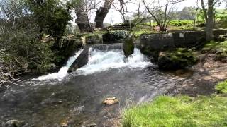
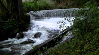
From Dulverton the river passes through Beasley Weir. Beasley Weir was built in 1909 and was known as Beasley Power Station, a hydro-electric generating plant and provided the first electricity to Dulverton. There is a large Salmon ladder and from 1950 until 1980 the site was used as a fish breeding station. In 2016 t a new hydropower system was built which generates enough electricity to power 100 homes.
Continuing on the river flows below New Bridge, a Grade ii listed structure built in 1870 to provide access to Pixton Park, and then beneath Perry New Road, and finally Perrys Weir before reaching its confluence with the Little Exe to form the River Exe which then flows on for approximately 40 miles to reach the Exe Estuary and the English Channel at Exmouth. The river Barle’s journey from source to its confluence with the Little Exe is approximately 39 kilometres and the river has fallen from its height at source of 1450 feet to 380 feet at its end.
Source: Elevation 443.1 m or 1453.7 feet – Location :51.16550,-3.82781
Click the button below to watch a playlist of videos showing the river’s journey from source to confluence with the River Exe. A gallery of the individual playlist videos is also shown.
Badgworthy Water is formed by streams that run from East and West Penford and Trout Hill, Long Combe and Lark Barrow. It flows in a northerly direction and is joined on the south side of Badgworthy Hill by its main tributary, Hoccombe Water. It flows through Doone country, between Badgworthy Lees and South Common. It continues east of Malmsmead Hill and Its journey ends when it is joined by Oare Water near Malmsmead, to form the East Lyn River.
During its approximately 5.6 kilometre journey it is joined by Hoccombe Water, waters from Clanna Combe and Hoccombe Combe, Withycombe Bridge Water, waters from Lank Combe and Land Combe, Yealcombe Water, waters from Shir Combe and Yeal’s Combe, and after passing Cloud Farm it is joined by Bus Lawn Water, and waters from Bus Combe, and Wat Combe.
Source: Head stream on Little Buscombe – Elevation 435.2 m or 1427.7 feet – Location :51.16534,-3.76145
The River Avill rises west of Dunkery Hill Gate at an elevation of approximately 420 metres. It flows through Mansly Combe where it is joined with further headwaters from the eastern side of Dunkery Hill. After leaving Mansly Combe it is joined by waters from Bin Combe and then flows in a generally easterly direction north of Wheddon Cross. After flowing through Snowdrop Valley (Hawkwell Wood) the river continues on through Steart where waters join from Kersham hill. The river flows on beneath Pitt Bridge, past Bickham Manor and then Timberscombe where waters join that rise in the hills south of Timberscombe, and further waters join from the north that rise in Hanney Combe. It then flows south of Grabbist Hill before reaching Dunster and flowing through the grounds of Dunster Castle. After leaving Dunster Castle the river flows beneath Loxhole Bridge which carries the A39 before reaching the Bristol Channel on Dunster Beach,. The rivers length from source to the sea is approximately 16 kilometres.
Dunster Mill within the grounds of Dunster Castle is powered by waters of the Avill. A leat formed from a weir south of Grabbist Hill runs for approximately one kilometre to reach the restored 18th century watermill and provides the water that drives the mill’s two overshot waterwheels.
At Loxhole Bridge a one kilometre sluice controlled overflow channel has been constructed to take water from the river into the Bristol Channel just east of the river’s mouth.
Source: Elevation 420.2 m or 1378.5 feet – Location :51.15586,-3.58781
The river has a complicated system of headwaters that join to form the main river. The head streams that rise to the west of Wootton Courtenay flow in a northerly direction and are joined by head streams that rise near Tivington. These head streams turn to the west where they are joined by head streams that rise in the hills above Huntscott and then later, at Blackford, by head streams that rise above Luccombe Mill. The combined waters then flow in a north westerly direction through Stratford Wood where head streams that rise on Luccombe Hill join. The river now in its full flow continues in a north westerly direction to flow through the Holnicote Estate, Piles Mill, Brandish Street, Allerford and Lynch Bridge before joining Horner Water at Bossington and flows into Porlock Bay near Hurlestone point on the Bristol Channel.
Allerford Bridge
From the headwaters near Wootton Courtenay to its confluence with Horner Water the river travels a distance of approximately 4.5 miles with a fall in elevation of close to 110 metres.
Source: Elevation 134.8 m or 442.3 feet – Location :51.18843,-3.52676