The River Avill rises west of Dunkery Hill Gate at an elevation of approximately 420 metres. It flows through Mansly Combe where it is joined with further headwaters from the eastern side of Dunkery Hill. After leaving Mansly Combe it is joined by waters from Bin Combe and then flows in a generally easterly direction north of Wheddon Cross. After flowing through Snowdrop Valley (Hawkwell Wood) the river continues on through Steart where waters join from Kersham hill. The river flows on beneath Pitt Bridge, past Bickham Manor and then Timberscombe where waters join that rise in the hills south of Timberscombe, and further waters join from the north that rise in Hanney Combe. It then flows south of Grabbist Hill before reaching Dunster and flowing through the grounds of Dunster Castle. After leaving Dunster Castle the river flows beneath Loxhole Bridge which carries the A39 before reaching the Bristol Channel on Dunster Beach,. The rivers length from source to the sea is approximately 16 kilometres.
Dunster Mill within the grounds of Dunster Castle is powered by waters of the Avill. A leat formed from a weir south of Grabbist Hill runs for approximately one kilometre to reach the restored 18th century watermill and provides the water that drives the mill’s two overshot waterwheels.
At Loxhole Bridge a one kilometre sluice controlled overflow channel has been constructed to take water from the river into the Bristol Channel just east of the river’s mouth.
Source: Elevation 420.2 m or 1378.5 feet – Location :51.15586,-3.58781

Video Gallery

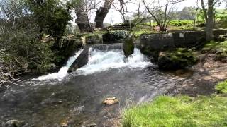
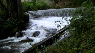
Image Gallery Location Map Structures