Lawns’ Bridge

Bridge Name: Lawns’ Bridge
No.: 22
Location: SS 9929 4347
Build Date: Late 18th century
Engineer: Richard Phelps

Description:
Late 18th century. Stone built with three semi-circular arches, wider central arch with depressed triangular parapet. Moulded stone copings to parapets and abutment walls. Rock-faced rusticated pilasters and voussoirs.
English Heritage Listed Building Number: 264653. First Listed on 04/08/1983. An 18th-century bridge spans the River Avill at SS 9930 4347. It is Palladian in style, with three arches. The vouissoirs are of undressed stone to give a picturesque appearance. The rest of the structure is of local mortared stone, capped with sandstone slabs. An artificial waterfall below the bridge adds to the effect. The bridge was designed by Richard Phelps, and is part of the 18th century enhancement of the grounds of Dunster Castle, for H F Luttrell. The bridge leads from the formal grounds around the castle, out towards the Deer Park.1

References:

1.Exmoor National Park HER – MSO12063

Lovers’ Bridge

Bridge Name: Lovers’ Bridge
No.: 20
Location: Mill Lane, Dunster – SS 9916 4333
Build Date: eighteenth century
Engineer: Richard Phelps

Description:
Mid/late 18th century; picturesque bridge built by HF Luttrell (of Dunster Castle) to replace medieval mill bridge over River Avill. Brick and stone. Two pointed arches. Low brick parapet south side. Parapet to north side raised but damaged. Rock faced rusticated voussoirs.
English Heritage Listed Building Number: 264701. First Listed on 04/08/1983. An eighteenth century bridge spanning the River Avill in the grounds of Dunster Castle lies at SS 9916 4333, 200m upstream from the Palladian bridge (PRN 34921). The bridge is built in a “rustic” style, designed to be viewed from the north. The double-arched span curves over the river, and a waterfall and island have been created downstream. The bridge is built of local stone with a brick capping. A brick seat is built into the parapet. The northern side is faced with undressed stone and pebbles to create a rustic effect; the southern face is plain. The bridge takes a footpath over the river and out of the Castle grounds towards the Deer Park. It was designed by Richard Phelps, and is part of the 18th century enhancement of the grounds of Dunster Castle, for H F Luttrell.1

References:

1.Exmoor National Park HER – MSO12106

Gallox Bridge

Bridge Name: Gallox Bridge
No.: 19
Location: Dunster – SS 9895 4321
Build Date:

Engineer:

Description:
Gallox Bridge on the River Avill, is a packhorse bridge with two slightly pointed arches and a roadway width of c3ft 3ins.
Bridge length 10.5m and 1.2m wide. The two arches are slightly pointed and have double arch rings. Each side has four narrow chamfered ribs. There is a cut-water on the upstream side only. The bridge leads to a causeway skirting a ford on the N side.Also a listed building,Scheduled area revised with new national number on 28 June 1996, was Somerset 149.1
June 3, 1662. Payd to Francis Hill for repayring a bridge by Dunster. 2

References:

1.Exmoor National Park HER – MSO11991
2. History of hundred of Carhampton, in the County of Somerset, from the best authorities by James Savage

Frackford Bridge

Bridge Name: Frackford Bridge
No.: 18
Location:

Build Date:

Engineer:

Description:
References:

1.Exmoor National Park HER – MSO12153
2.Somerset Roads The Legacy of the Turnpikes – JB.Bentley & B J Murless

Old Frackford Bridge

Bridge Name: Old Frackford Bridge
No.: 17
Location: Dunster – SS 9846 4325
Build Date: C18
Engineer:

Description:
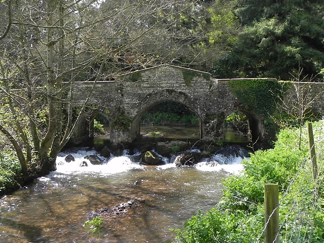
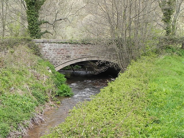
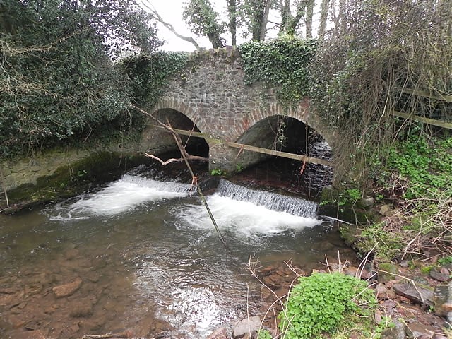
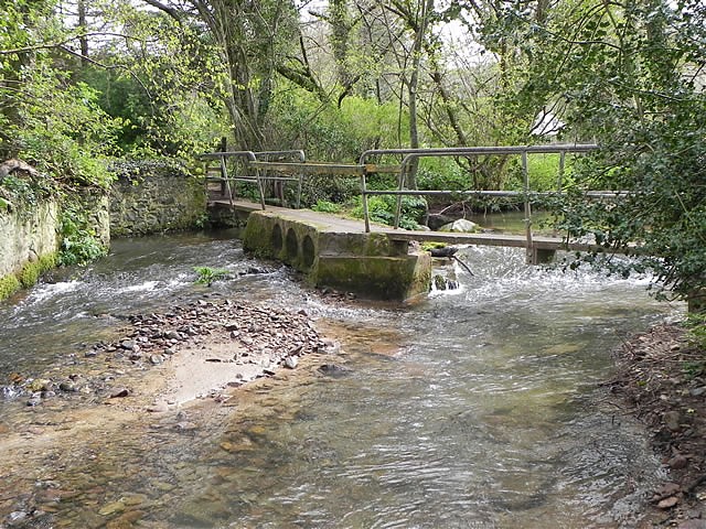
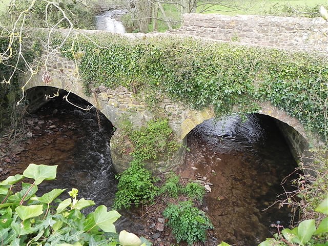
A C18 bridge formerly carring the Dunster to Timberscombe road. Replaced by a new bridge in 1913.
Dated 1768, builders William and George Rawle. Random rubble sandstone. Two semi-circular arches, later triangular coping to parapets, partly overgrown with ivy at time of survey. Date and names carved on slate let into east face. No longer in use, replaced by present single span bridge in 1913. English Heritage Listed Building Number: 264748. First Listed on 04/08/1983. A double span bridge of local red sandstone spans the River Avill at SS 9846 4325. It is now bypassed by the A396 road bridge. Frackford Bridge was built in 1768 by William and George Rawle (names and date carved in slate on east face). The bridge is overgrown with vegetation and is beginning to deteriorate. The bridge has been recently mended but the slate recording “William and George Rawle Builders 1768” has fallen off leaving only the initial “W”. The replacement reinforced concrete arch bridge was built in 1913 and designed by Edward Stead, County Surveyor. Copings, stringcourses and quoins are of ashlar masonry with the remainder of the masonry rock faced. The end of the concrete deck is exposed in elevation. The bridge is 23 feet in span.1
The bridge at Frackford, now Frackford Old Bridge, carried the main route from Exmoor to Dunster and the coast. It was an important bridge, probably replacing a ford. In 1307 Richard of Avill left 12d towards its upkeep. The prior of Dunster and Avill tithing were required to repair it in 1476. The route was turnpiked in 1765 by the Minehead Trust to the Devon boundary beyond Dulverton. Frackford Bridge was built with two arches in 1768 by local masons William and George Rawle. The coping was added later.It was replaced by the present stone and concrete single-span bridge built alongside in 1913 for Somerset County Ccouncil to the designs of County Surveyor Edward Stead.2

References:

1.Exmoor National Park HER – MSO12153 2.https://www.victoriacountyhistory.ac.uk/explore/items/dunster-bridges