Northern Mill – Winsford

Location :51.11125,-3.57285

A building shown on historic mapping situated adjacent to a possible leat fed by the River Exe may be a historic watermill. It has been suggested that the presence of a building named Northern Mill Cottage may indicate a corn mill was situated in this vicinity. Field investigation could provide no trace of such a building.

References: Exmoor HER – MEM22327 – Possible post-medieval mill and mill leat near Northern Mill Cottage and MSO8596 – Possible post-medieval mill at Northern Mill Cottage

Full Description

MEM22327
Watercourse fed by the River Exe, probably a leat, and a building (at SS 8999 035841) which could therefore be a mill, shown on Winsford Tithe Map south west of the river and Northern Mill Cottage. The tithe apportionment has not been checked and may provide further information.
Neither building nor possible leat are shown on the 1st Edition Ordnance Survey Map, although their position is in part suggested by field boundaries.
Record MSO8596 notes the possibility of a mill in this vicinity

MSO8596                                                                                                                                                                                `Northern Mill Cottage’ at SS 9003 3590. Possible corn mill in the vicinity?
‘Northern Mill Cottage’ is mentioned on the 1st Edition 1890 Ordnance Survey map, the 2nd Edition map and the 1962 6 inch map.
No visible remains were noted by D Warren in 1977. 
There is no evidence of a mill at or in the vicinity of Northern Mill Cottage.
There is a water course fed by the Exe, probably a leat, and a building (at SS 89990 35841) shown on Winsford Tithe Map on the southern side of the River Exe, to the south west of Northern Mill Cottage see also MEM22327

See also:


Puzzlecombe Weir

Location :51.02698,-3.52025

A leat leads from the weir, directed by a sluice, to Perry Cottages and beyond. N.B. This leat continues to the south of the National Park boundary.

References: Exmoor HER – MEM24816 – Post-medieval leat south of Puzzlecombe Weir and MEM23676 – Puzzlecombe Weir

Full Description
MEM24816
A leat is shown on the Tithe Map for Dulverton. It begins at Puzzlecombe Weir (MEM23676, SS 9345 2636), where it is directed southwards to the west of the River Exe, to a building at SS 9342 2598 (MEM24817). At this point, the leat passes outside the National Park boundary and leads southwards, until it feeds into the River Barle at SS 9323 2534.
The leat is shown on the 25 inch 1st Edition Ordnance Survey map. This map labels a sluice at the weir, to control water flow into the leat, and also depicts another sluice feeding an overflow leat from the main leat back into the Exe, from SS 9344 2600 to SS 9347 2599.
The 25 inch 2nd Edition map shows a similar layout to the 1st Edition map.
The 2018 MasterMap data suggests that much of the route of the leat no longer appears to be extant within the National Park boundary, although it may simply have been omitted from the data.
MEM23676
A weir is shown on the Tithe Map for Dulverton at SS 9347 2638 on the River Exe. The river is labelled 2267 at this point, which the Apportionment states was owned by the Trustees of the Minehead Turnpike Roads.
The feature is shown and labelled “Puzzlecombe Weir” on the 1st Edition Ordnance Survey map.
It is again shown on the 2nd Edition map.
The weir appears to be no longer extant. The river has also changed shape at this location.

Kent’s Mill

Location :51.06915,-3.53733

A post-medieval mill complex, thought to be of 19th Century date. A leat survives, with sluices and traces of a wheel pit and fed by Kent’s Weir to the east. The mill building has been converted to a dwelling. There may be an associated field gutter system.

References: Exmoor HER – MMO594 – Kents Mill and Kent’s Weir, Brompton Regis (Building)

Full Description

A post-medieval mill complex at Kents Mill thought to be 19th Century. The surviving features are a leat with sluices.
Mill now gutted and a dwelling. Trace of wheel pit. Site suggests a low breast wheel.
A rectangular building is shown on the Tithe Map for Brompton Regis at c. SS 9237 3110, orientated north to south. There is a further building slightly to the southeast orientated east to west, at c. SS 9238 3110, and another outbuilding to the west at c. SS 9235 3112. A leat runs east to west, fed from the River Exe at SS 9259 3111 and running back into the River Exe further downstream at SS 9230 3113. The leat runs to the north of the buildings, with the main rectangular building built with its northern elevation adjacent to the leat.
The group of buildings is within a group of enclosures labelled 1197 on the Tithe Map, which the Apportionment describes as “Millhouse Gardens Orchards etc”.

The main rectangular building and the western outbuilding are shown on the 25 inch 1st Edition Ordnance Survey map. The southeastern building appears to have been demolished. The main building is labelled “Kentsmill Cottage”. A secondary leat, with an aqueduct to carry it over the original structure at SS 9232 3112, is diverted from the main leat at SS 9242 3111 (see MEM25338). A large weir is shown where the water is taken from the River Exe to the east; this is labelled “Kent’s Weir”.
The site is similarly depicted on the 25 inch 2nd Edition Ordnance Survey map. The main millhouse has been extended in two subdivided parts on the western elevation. A footbridge is labelled over the leat directly to the northeast of the house.

The 2022 MasterMap data shows the main leat is still extant. The secondary leat, including the aqueduct (MEM25338), appears to have been removed. The site is labelled “Kents Mill”; “Kent’s Weir” is also depicted and labelled.

See  also: 

Westermill Farm – Post-medieval watermill

Location :51.14592,-3.68238

A mill is recorded at the farm in documents pertaining to the 1815 perambulation of Exmoor. It generated electricity during the mid 20th Century.

References: Exmoor HER – MSO11263 – Post-medieval watermill at Westermill Farm
Full Description
Local tradition of a watermill here fed by a long leat from the west side of River Exe. [1]
No visible signs at mill site but leat traceable in parts from Sparkham Water. The waterwheel generated electricity installed in 1957 and removed 1963.
Mentioned in the 1815 perambulation – “proceeds in the same direction near certain old Inclosure called West Mill farm..”.

See also:


Edgcott Mill, Exford

Location :51.13613,-3.64928

The mill and associated leat are shown on historic mapping.

References: MSO11267 – Edgcott Mill, Exford

Full Description
Leat from River Exe and tail race, now dry. Had an overshot wheel.
Edgcott mill and leat are depicted on the Tithe Map for Exford. The mill building is shown at SS 8473 3869 and the leat takes water from the River Exe at SS 8457 3875, running down to the mill and then returning to the river at SS 8482 3863. The leat is labelled 637 but unfortunately, the number on the mill building is too difficult to determine on the copy of the map viewed. The accompanying Apportionment document describes 637 as “Mill Leat” (there is no obvious description that would sit with the mill building), both owned and occupied by John Hooper.
The mill and leat are both shown on the 1st Edition Ordnance Survey map and on the 2nd Edition map (as mentioned above). The leat appears to run the same course as it did on the Tithe Map. A weir is marked on the Exe from where the water is drawn for the leat.
Since the 2nd Edition Map was surveyed, the leat appears to have been filled in. The mill building may still be extant

See also:

Bridgetown Mill

Location :51.06541,-3.53712

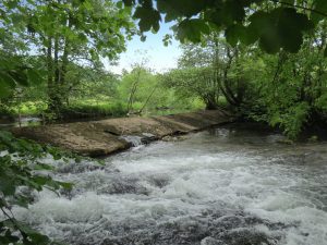
A mill leat is recorded on historic mapping. It carries water from a weir on the River Exe to Bridgetown Mill to the south. A weir is marked on historic mapping, with the downstream side labelled “Shetter’s Pool”. A leat leaves the river on the upstream side of the weir. A salmon leap is also present on the weir. A mill is recorded on historic mapping and has a low breastshot water wheel.

References: Exmoor HER – MEM24927 – Post-medieval mill leat at Bridgetown, and MEM24926 – Shetter’s Pool and post-medieval weir north of Bridgetown, and MEM15204 – Bridgetown Mill, Exton

Full Description

MEM24927 – The Tithe Map for Exton Parish depicts a mill leat commencing at a weir on the River Exe north of Bridgetown, at SS 9233 3376. It runs south to a mill situated at SS 9233 3330 (MEM15204) before returning to the Exe at SS 9232 3321.
The feature is depicted on the 25 inch 1st Edition Ordnance Survey map and is labelled “Mill Leat”.
The leat is also shown on the 2021 MasterMap data.
A report relating to works undertaken at Bridgetown Weir mentions the history of the mill . There appears to be no documentary evidence for the mill and leat prior to the mid 19th Century, although a draft conveyance of a water mill in Exton dating from 1827 and held in the Somerset Heritage Centre may refer to the water mill at Bridgetown. There is no clear evidence for the leat on the surveyors draft maps of the area, although it is limited in detail and a boundary shown does run along its approximate line.
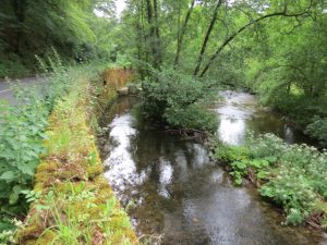
The leat runs broadly parallel to the river for c. 450 metres down to the mill. It is flanked by a retaining wall for the A396 road, and by a low wall of dressed blocks to the west. It has a sharp rectangular profile, deep and carrying a large volume of water, and is well maintained. A relatively modern sluice gate is between the leat and river.

MEM24926 – The Tithe Map for both Winsford and Exton Parishes depicts a mill leat leaving the River Exe at SS 9232 3377. The river forms the boundary between the two Parishes.
The 25 inch 1st Edition Ordnance Survey map depicts a weir in this location, with the downstream side labelled “Shetter’s Pool”. A leat (MEM24927) leaves the river on the upstream side of the weir, which may have been constructed to facilitate this.
The weir is shown and labelled on 2021 MasterMap data, as is the pool. The leat also appears to be in situ at this time. A salmon leap is also labelled on the northwestern end of the weir, at SS 9231 3378.
A programme of archaeological monitoring and recording was undertaken during the permitted works to Bridgetown Weir, situated on the River Exe. An assessment was undertaken in 2021, the results of which were combined with further recording during works in August 2022.
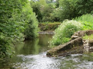
The structure is built as a long cranked diagonal weir, with a sluice and leat to the southsoutheast and a fish passage inserted to the northwest. It is mainly built of local sandstone, shale and slate, with later additions of concrete and cement braced with iron pins and wires. All of the weir(s)’ elements would be described as low guage weirs; the northern element is in the form of an earlier crump weir and the lower element to the southern end is classed as a narrow crested drop weir, associated with the leat and sluice gate to the mill and possibly a later reconstruction. The overflow gate, flank wall and sluice gate are of a neat, functional character and are of the same build. A section of shuttered concrete associated with blocks and cement filled sandbags infills the former overflow gate. There are two phases of mixed stone builders at the southern end, pinned in front and possibly intended to alter the water flow here and strengthen the structure.
The weir is associated with a mill leat (MEM24927) that leads to Bridgetown Mill (MEM15204). The regularity of the banks above the rear, which feature underbuilding and revetment banking to sections of the western riverbank, were stated to suggest the course of the river has been considerably engineered at this location to serve the mill.
A draft conveyance of a water mill in Exton dating from 1827 and held in the Somerset Heritage Centre may refer to the water mill at Bridgetown. The surveyors draft maps show no clear evidence for the weir weir and pool, although they may have been in existance by this date.
A further document dated 1954 relates to the installation of the fish pass. This is possibly associated with the establishment of the National Park, with the pool in front formed in 2012 by the Westcountry Rivers Trust. It has thick cinder wall blocks rendered in cement and runs straight through the weir, widening into a square bowl at the end, emptying into a pool. It was designed to allow the structure to be closed off, but any sluice gate that was extant has been removed or rotted away. 


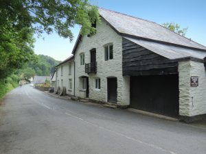
MEM15204 – The mill has a low breast all iron wheel, 14′ diameter, 4′ wide, with 19″ deep side plates and 40 paddles curved to 23″ deep.
The mill building shows on the 1st and 2nd ed. Ordnance Survey mapping as “Bridgetown Corn Mill”.
The mill is mentioned in a publication on the industrial archaeology of Somerset, which states that the late 19th Century machinery is in full working order, although no longer grinding, and is now incorporated into the building’s living space.
The building is labelled “Mill House” on the 2022 MasterMap data.
A report relating to works undertaken at Bridgetown Weir mentions the history of the mill and its occupants. A draft conveyance of a water mill in Exton dating from 1827 and held in the Somerset Heritage Centre may refer to the water mill at Bridgetown. The surveyors draft map for the area may or may not show a building in this location, which if present appears to have been on a different orientation to the building shown on the Tithe Map.


Weir Saw Mills.

Location :51.03040,-3.52019

Weir Saw Mills is marked on historic mapping. It is known to have had a modern wheel driving generator and saw benches in an old wheel pit. The weir is shown on historic mapping on the River Exe diverting water into a leat. There is a leat from Helebridge Weir though Rock Wood to the Weir Saw Mills.

References: Exmoor HER – MEM25086 – Helebridge Weir and MEM22030 – Leat from Helebridge Weir, Dulverton and MSO9355 – Weir Saw Mills / The Old Sawmills, Weir Bridge, Dulverton

Full Description
There is a long leat from Helebridge Weir, at SS93302770, though Rock Wood to the Weir Saw Mills.
The 1st Edition Ordnance Survey map depicts a weir on the River Exe, diverting water into leat MEM22030. The feature is labelled “Helebridge Weir”.

‘Weir Saw Mills’ is marked on the 1st and 2nd Edition Ordnance Survey maps.
‘Mills’ are printed on the 1962 Ordnance Survey map.
The sawmill is known to have had a modern wheel driving generator and saw benches in an old wheel pit.
This was a working sawmill until about the 1980s. The prepared oak timbers were taken to Minehead for ship building. It was part of the Pixton Estate. There is a datestone of 1866.
The housings for the wheel have been found, and there is a tunnel about 12-15 feet below the cellar.

See also:

Pitcott Corn Mill, Winsford

Location :51.10167,-3.56134

The mill building is shown on historic mapping and was owned by the Aclands in the 19th Century. Part of the timber boarded frontage remains. The mill site is shown on historic mapping and was owned by the Acland family. The mill building is now converted to a dwelling. Other associated remains include a weir, wheel pit, leat, and sluices and a mill house

References: Exmoor HER – MEM23607 – Pitcott Mill and MSO8590 – Pitcott Corn Mill, Winsford 

Full Description

MEM23607
A building is shown on the Tithe Map for Winsford at c. SS 9075 3475, orientated northeast to southwest and overhanging a leat that feeds from and into the River Exe. It is described in the accompanying Apportionment under land parcel 660 as a mill house, owned by Sir Thomas Dyke Acland and occupied by Joan Milton.
The building is shown in a similar layout on the 1st and 2nd Edition Ordnance Survey maps, within an area of land labelled “Pitcott Corn Mill”.
Modern MasterMap data labels the property Pitcott Mill.
Pitcott Corn Mill, a post-medieval building, has now been converted to a dwelling. Other remains include a wheel pit, leat, and sluices.
Pitcott Mill, stepped down the slope is a former corn mill served by a leat from the River Exe. Part of the timber boarded frontage remains.
MSO8590
A mill site is depicted on the Tithe Map for Winsford, including a leat, mill house (MEM23607) and house (MEM23605) with two small associated outbuildings at c. SS 9072 3476 and SS 9073 3477. The accompanying apportionment states that the land owned by the mill includes the mill house and house, and areas of meadow (“Close,” “Moory Mead” and “Withy Bed”), pasture (“Mill Ham and “Lower Broom Close”), arable (“Higher Broom Close”) and orchard (“Bridgend Orchard” and “Mill House Orchard”).
‘Pitcott Corn Mill’ and a ‘Mill Leat’ are labelled on the 1st Edition Ordnance Survey 25 inch map.
‘Pitcott Corn Mill’ and a ‘Mill Leat’ are labelled on the 2nd Edition Ordnance Survey 25 inch map
‘Mill Leat’ is labelled on the Ordnance Survey 1962 6 inch map.
Pitcott Corn Mill, a post medieval building, has now been converted to a dwelling. Other remains include a wheel pit, leat, and sluices. The wheel pit and wall show scoring, indicating that the wheel measured 10 feet in diameter by 3 feet in width. The stone weir on the River Exe, at SS 906 349, and the leat to SS 9095 3470 are in good condition, and are maintained by the Devon River Board.

See also:

Lower Mill, Higher Mill Farm (Edgcott)

Location :51.13947,-3.65499

A mill and leat are recorded on historic mapping. It was gifted by Robert Baker in 1755, with the proceeds used to clothe the poor of Hawkcombe and Exford Parishes. The corn mill was powered by an overshot wheel made by John Brayley of Molland in 1870.

References: Exmoor HER – MSO11250 – Lower Mill, Higher Mill Farm

Full Description
“Mill leat” printed on Ordnance Survey Aarchaeological Division 6 inch map.
Leat from tributary of River Exe from SS 8412 3960. Iron trough, relief hatches etc. Overshot wheel with 36 wooden buckets. Pit wheel 56 feet by 4 feet.
Higher Mill and Lower Mill are indicated on Exford Tithe Map and the Ordnance Survey 1st and 2nd Edition maps with a leat indicated running south from a weir on the Allcombe Water (at the grid refence above SS 8412 3960) running west of Downscombe Farm. The building labelled Lower Mill (SS 8431 3911) was the mill building, labelled 1138 on the Tithe Map, owned by the Poor of Exford and occupied by Richard Court. The main leat is shown flowing under the building on the Tithe Map, but a major diversion is shown on the 1st and 2nd Edition map to the northwest, with an offshoot instead flowing to the building. It is marked as a corn mill on this map.
On 7th January 1755, Rober Baker willed his messuage or tenement of Lower Mill to Francis Squire (then Rector of Exford), and various other named persons in Trust (the number was to remain at ten, with new trustees elected by the remainder). 40 shillings (two pounds) was to be paid annually on the first Sunday after the Feast of All Saints for the use of the poor of Hawkridge parish, in order to clothe those most in need. The remainder was to be distributed as clothing amongst the poor of Exford at Christmas.
The property was noted to have a dwelling house, millhouse, malthouse, a cottage and garden, with six acres of land, all let for 20 pounds 7 shillings a year.
The building is mentioned in a publication on the industrial archaeology of Somerset. Lower Mill is noted to have an overshot wheel made by John Brayley of Molland in 1870. The leat runs alongside the road, fed by the Allcombe Water.

See also: