Location :51.03040,-3.52019
Weir Saw Mills is marked on historic mapping. It is known to have had a modern wheel driving generator and saw benches in an old wheel pit. The weir is shown on historic mapping on the River Exe diverting water into a leat. There is a leat from Helebridge Weir though Rock Wood to the Weir Saw Mills.
References: Exmoor HER – MEM25086 – Helebridge Weir and MEM22030 – Leat from Helebridge Weir, Dulverton and MSO9355 – Weir Saw Mills / The Old Sawmills, Weir Bridge, Dulverton
Full Description
There is a long leat from Helebridge Weir, at SS93302770, though Rock Wood to the Weir Saw Mills.
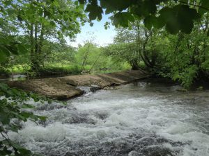
The 1st Edition Ordnance Survey map depicts a weir on the River Exe, diverting water into leat MEM22030. The feature is labelled “Helebridge Weir”.
‘Weir Saw Mills’ is marked on the 1st and 2nd Edition Ordnance Survey maps.
‘Mills’ are printed on the 1962 Ordnance Survey map.
The sawmill is known to have had a modern wheel driving generator and saw benches in an old wheel pit.
This was a working sawmill until about the 1980s. The prepared oak timbers were taken to Minehead for ship building. It was part of the Pixton Estate. There is a datestone of 1866.
The housings for the wheel have been found, and there is a tunnel about 12-15 feet below the cellar.
See also:
- http://www.pastscape.org.uk/hob.aspx?hob_id=1114474 (Pastscape entry: 1114474)