Location :51.10167,-3.56134
The mill building is shown on historic mapping and was owned by the Aclands in the 19th Century. Part of the timber boarded frontage remains. The mill site is shown on historic mapping and was owned by the Acland family. The mill building is now converted to a dwelling. Other associated remains include a weir, wheel pit, leat, and sluices and a mill house
References: Exmoor HER – MEM23607 – Pitcott Mill and MSO8590 – Pitcott Corn Mill, Winsford
Full Description
MEM23607
A building is shown on the Tithe Map for Winsford at c. SS 9075 3475, orientated northeast to southwest and overhanging a leat that feeds from and into the River Exe. It is described in the accompanying Apportionment under land parcel 660 as a mill house, owned by Sir Thomas Dyke Acland and occupied by Joan Milton.
The building is shown in a similar layout on the 1st and 2nd Edition Ordnance Survey maps, within an area of land labelled “Pitcott Corn Mill”.
Modern MasterMap data labels the property Pitcott Mill.
Pitcott Corn Mill, a post-medieval building, has now been converted to a dwelling. Other remains include a wheel pit, leat, and sluices.
Pitcott Mill, stepped down the slope is a former corn mill served by a leat from the River Exe. Part of the timber boarded frontage remains.
MSO8590
A mill site is depicted on the Tithe Map for Winsford, including a leat, mill house (MEM23607) and house (MEM23605) with two small associated outbuildings at c. SS 9072 3476 and SS 9073 3477. The accompanying apportionment states that the land owned by the mill includes the mill house and house, and areas of meadow (“Close,” “Moory Mead” and “Withy Bed”), pasture (“Mill Ham and “Lower Broom Close”), arable (“Higher Broom Close”) and orchard (“Bridgend Orchard” and “Mill House Orchard”).
‘Pitcott Corn Mill’ and a ‘Mill Leat’ are labelled on the 1st Edition Ordnance Survey 25 inch map.
‘Pitcott Corn Mill’ and a ‘Mill Leat’ are labelled on the 2nd Edition Ordnance Survey 25 inch map
‘Mill Leat’ is labelled on the Ordnance Survey 1962 6 inch map.
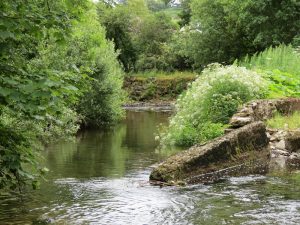
Pitcott Corn Mill, a post medieval building, has now been converted to a dwelling. Other remains include a wheel pit, leat, and sluices. The wheel pit and wall show scoring, indicating that the wheel measured 10 feet in diameter by 3 feet in width. The stone weir on the River Exe, at SS 906 349, and the leat to SS 9095 3470 are in good condition, and are maintained by the Devon River Board.
See also:
- http://www.pastscape.org.uk/hob.aspx?hob_id=1095099 (Original Monarch entry: 1095099)