Bridgetown Bridge

Bridge Name: Bridgetown Bridge
No.: 24 
Location: SS 92267 32136
Build Date: Probably 19th century
Engineer:

Description:

Single arch built of local stone. Carries Week Lane
About two and a half miles below Winsford the Exe is crossed by a narrow stone bridge known as Bridge-Town Bridge. It has one semicircular arch built of rather rough masonry.1

References:

1. The Ancient Bridges of the South of England – Jervoise

Week Bridge

Bridge Name: Week Bridge
No.: 23 
Location: SS 92179 34184
Build Date: 1926
Engineer: Edward Stead

Description:
Reinforced concrete slab bridge built in 1926 and designed by Edward Stead, County Surveyor. Bridge has stringcourse and level coping.The bridge is 15 feet in span.1

References:

1.Exmoor National Park HER – MSO10139

Edbrooke Packhorse Bridge

Bridge Name:

Edbrooke Packhorse Bridge
No.: 20 
Location:SS 9117 3421
Build Date: 18th century
Engineer:

Description:
packhorse bridge of possible medieval origin over the River Exe. It was rebuilt in the 18th century.
Packhorse bridge over River Exe. Possibly medieval in origin, rebuilt C18. Local stone random rubble, rubble voussoirs, slate coping. Two arch span, semicircular arches, small cutwater on upstream side only, probably pebble pavement to narrow pathway. The road to Winsford passed over the bridge until the new turnpike road was cut in 1824. 1

Edbrooke, below Winsford, is the site of another ancient packhorse bridge on a former route from the Quarme valley up to Winsford Hill. It was rebuilt in the 18th century and carried the road to Winsford until the new turnpike road
was made in 1824. (2)


References:

1.Exmoor National Park HER – MSO8546

2. THE RIVER EXE – Victoria County History – Mary Suirat University of London


Exe Bridge – Winsford

Bridge Name: Exe Bridge
No.: 19 
Location: Winsford SS 90702 34904
Build Date: circa 1952
Engineer:

Description:

But then of course they had the Lynmouth flood, which sort of changed everything. Because Brookwood used to get regularly flooded, because, going over Howetown Lane, Exebridge, it’s called, there’s a big bridge there, on the way to the recreation field. And it was a stone arch bridge with 3 pillars. So immediately they had the high water that all got blocked up with rubbish and sticks and what have you, and used to cause flooding in the village. Well anyway, in the Lynmouth that was all washed away, and a single span bridge has been built since, and to his knowledge there has only been water out in the village twice since the Lynmouth flood. And on the first occasion it just crept into Brookwood, but nothing very much. 1

The Lynmouth Flood occurred on 15th August 1952 when 9 inches of rain fell on the Exe Plain and the Chains. The pressure of the rush of water down the Exe destroyed the old arched bridge in Howetown Lane, with driftwood, trees and roots blocking the arches. Once the bridge gave way the water level began to subside. 2

References:

1. http://www1.somerset.gov.uk/archives/exmoor/barwicksummary2.htm

2. Exmoor HER MEM23655

Vicarage Bridge

Bridge Name: Vicarage Bridge
No.: 18
Location: SS 9061 3517
Build Date: 1835
Engineer: Reconstructed by Edward J Stead, County Surveyor, and built by G B Fisher and Sons.
Description:
A three-arched road bridge over the River Exe built in 1835 for the turnpike, bypassing the packhorse bridge to the west. It was widened in 1927-8 and restored in 1952. 1

Vicarage Bridge was an old stone bridge in medieval tradition, which was strengthened and widened in 1928, the old masonry being reinstated in the elevation. (Jervoise says it was pulled down and replaced). [2,3] [2]

Department of the Environment, List of Buildings of Special Architectural or Historic Interest , DOE(HHR) West Somerset Dist (Exford et al) Somer 2nd Jan 1986 83 (Index). SMO5109. 3


References:

1. Exmoor National Park HER MSO8542
2. THe Ancient Bridges of the South of England – Jervoise
3. Department of the Environment, List of Buildings of Special Architectural or Historic Interest , DOE(HHR) West Somerset Dist (Exford et al) Somer 2nd Jan 1986 83 (Index). SMO5109.

Winsford Packhorse Bridge

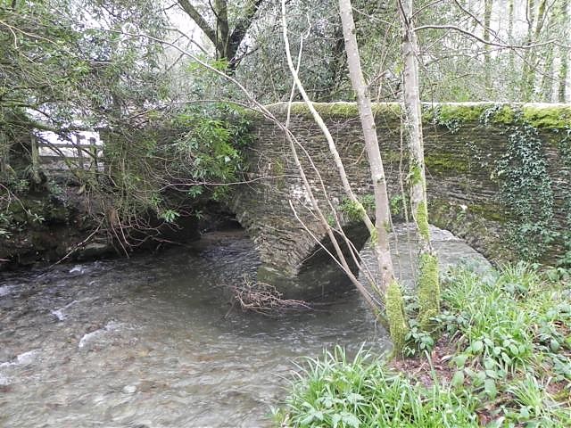
Bridge Name: Winsford Packhorse Bridge
No.: 17
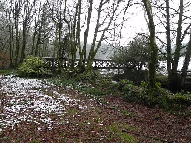
Location: Winsford SS 9057 3516
Build Date: probably medieval in origin. It was restored in 1952 following flood damage.
Engineer:

Description:

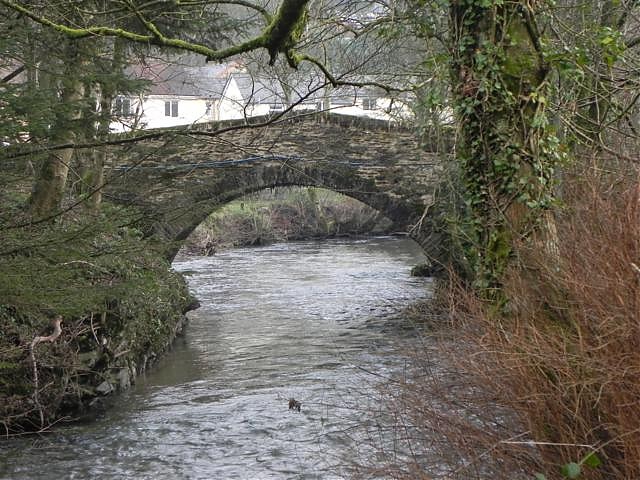
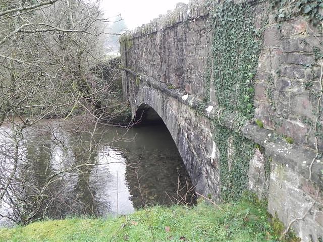
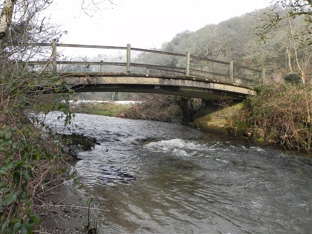
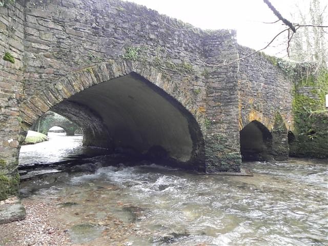
Packhorse Bridge (over river Exe). Listed Grade 2*. Picturesque narrow stone bridge with footway about 3 feet 6 inches wide with cobbles and stone parapets. It was restored following 1952 flood damage. Two semicircular head arches. Ancient Monument. [3]

The narrow bridge across the Exe at SS 9057 3516, some 40 metres west of the main bridge (Vicarage Bridge), is as described. Nonetheless, even allowing for some alteration in 1952, it is rather ornamental in appearance being built of coursed till-like stones. Also it is rather narrow for a packhorse bridge, and its parapets at 0.9 metres is rather high. More probably a footbridge than a packhorse bridge. [4]

Packhorse bridge close to Vicarage Bridge (MSO8542) at Winsford. It has two semicircular arches with a total span of about 30 feet.The width between the parapets is 3 feet 6 inches. This may be the bridge referred to as having been recently “re-edificed” in the Quarter Sessions of 1628. 2


References:

1. Exmoor National Park HER MSO8541
2. THe Ancient Bridges of the South of England – Jervoise

<3> Department of the Environment, List of Buildings of Special Architectural or Historic Interest , MHLG (Prov HHR) Dulverton RD Somer (September 1955) 22 (Index). SMO5109.

<4> Ordnance Survey Archaeology Division Field Investigators Comments, CF Wardale, 8 July 1986 (Unpublished document). SMO5103

Larcombe Foot Bridge ROW Bridge No. 1986

Bridge Name: Larcombe Foot Bridge ROW Bridge No. 1986
No.: 13
Location: SS 90702 34904
Build Date:

Engineer:

Description:

Concrete slab on RSJ’s supported on stone pillars, metal handrails. Carries bridleway DU 10/11. Rebuilt Feb/March 2023 (https://winsfordexmoor.org.uk/larcombe-foot-bridge/)

Probably built to replace  a post medieval footbridge (1)

References:

  1. Exmoor HER – MEM24998 – Post-medieval footbridge at Larcombe Foot. A footbridge is shown and labelled on the 25 inch 1st Edition Ordnance Survey map. The bridge is not shown on the 25 inch 2nd Edition map, suggesting it had been removed by this time. The bridge is also not shown on the Tithe Map for Winsford, although it is possible it was extant at this time.