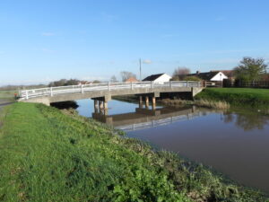
| Bridge Name: | Athelney Bridge | |||
| No.: | 86 | |||
| Location: | East Lyng – 51.05716,-2.93333 | |||
| Build Date: | ||||
| Engineer: | ||||
| Three span concrete structure. The single carriageway deck supported on two piers of 3 concrete columns seated in the river. Metal parapet. |
|
|||
| Description: | ||||
| Athelney bridge, where the former turnpike crossed the Tone south-east of Athelney island, was a two-arched wooden structure in 1791. The present bridge is of concrete.
The Taunton-Wells road keeps to the crest of the ridge and forms the main route through the parish. Its course until the early 19th century, turnpiked by the Taunton trust from 1752 to 1875, passed through West and East Lyng and then ran along the Baltmoor wall south of Athelney Farm to cross the Tone at Athelney Bridge. A new road was built between 1803 and 1806 across Salt moor from the eastern end of East Lyng village direct to Burrowbridge. Improved alignment there involved a new tollgate in 1804-5 and a tollhouse c. 18051 A bridge here was subject to an enquiry held at Somerton in the year 1280, when it was pleaded that “the Abbat of Alingneye was bound to repair the bridge.”2 Jervoise states in 1930 that the bridge was a girder structure and was probably previously a timber bridge The present Athelney bridge is of concrete, but the previous one, as recorded in 1791, was a two-arched wooden structure, where the former turnpike crossed the Tone south-east of Athelney island. The Taunton-Wells turnpike passed through West and East Lyng and then ran along the Baltmoor wall south of Athelney Farm to cross the Tone at Athelney Bridge. A new road was built between 1803 and 1806 across Salt moor from the eastern end of East Lyng village direct to Burrowbridge. (3) |
||||
| References: | 1. British History Online compid=18538 2. The Ancient Bridges of the South of England by E.Jervoise published in 1930 3. Stoke St.Gregory History Pages |
|||