Tracebridge Slate Cutting Mill

Circa 1894 a tunnel was constructed to run from the quarry floor of Tracebridge Slate Quarry to the banks of the river Tone. The tunnel was approximately 150 metres in length. A weir was built across the river to divert water through a short leat to enable an undershot water-wheel to provide the power for slate cutting machinery at the riverside. Small gauge rail track was installed in the tunnel to enable slate to be hauled in trucks from the quarry to the slate works, the tunnel also acted as an adit to take water from the quarry to the river. The loaded trucks were pushed by two men through the tunnel to the riverside and the cutting and planing sheds. The cut and finished slate was used for dairy slabs, water troughs and slate damp-proofing. The drum shown on the map below was the location for quarry waste. Circa 1920 a programme of modernisation in the quarry took place and the slate was prepared at road level. Consequently the river works were abandoned and gradually destroyed by quarry waste deposited in the river valley.


Today the only reminder of the artisans that worked the slate cutting mill are the ruins of two of the buildings and of course the tunnel which was constructed through solid rock by the miners.


References: Eric G Rodwell – Tracebridge. A History of the Hamlet, its Houses, The Quarries and the Mill.

Ttracebridge slate works
Tracebridge slate works

The above 1904 map published with permission from Ordnance Survey and Old-Maps.co.uk

Please note that the site is on private land and should not be visited without permission.

Broughton Brook Bridge


Bridge Name:   Broughton Brook Bridge
No.:   75A
Location:   Accommodation/foot bridge leading to Ruishton – 51.02245,-3.05747
Build Date:   1973
Engineer:   Monk


Description:   probably one of the smallest post-tensioned structures in the country. Chosen to be this
type so that it could be used as a trial for the main M5 bridge.
 
     
References:   Bridges Along the Tone – SCC Highways

Trenchard Way Bridge 

Firepool

Bridge Name:   Trenchard Way Bridge 
No.:   69B
Location:   Taunton 51.02122,-3.09430 – Carries the A3087  crosses both the River Tone and the Bridgwater & Taunton Canal
Build Date:   2017
Engineer:   Firepool road bridge, designed by HBPW Consulting engineers as part of the £22m Northern Inner Distributor Road (NIDR)


Description:    
 110 metres long three span steel concrete composite ‘ladder deck’ bridge
     
References:    

Stanmoor Bridge

Bridge Name:   Stanmoor Bridge
No.:   87
Location:   51.06711,-2.91757
Build Date:   Early 20th century circa 1901/2? (see 5. below)
Engineer:    
     
    The final bridge on the river Tone before its confluence with the Parrett.   


Description:   Single span girder bridge, with girders that rise above the road deck as the parapets.
Existed in 1685. Extracts from the churchwardens accounts show that money was expended on it’s repair. In 1685 the sum was £1 6s 8d and in 1687 a rate was made towards the building of the bridge. In 1688 a sum of £6 was paid to Mr.Collins towards the bridge and in 1690 £1 2s 0d was spent on 4 elms and 3 oaks and a further £1 7s 0d for raising the bridge ends with earth, and other expences for labour, etc., about the Bridge. In 1711 Thomas Walter was paid £1 18s 0d for repairs and a sum of £1 0s 0d was spent in respect of an order at the Quarter Sessions for rebuilding the bridge.

In 1740 several payments are made to a Mr Weech in respect of law about Stanmoor Bridge, these total £29.It would appear that the bridge was rebuilt in 1754 for a sum of £104(From an entry in 1809 9 -see below)

At a vestry meeting In 1780  It being now reported to this meeting that Stanmoor Bridge a public Bridge lying in this Parish is now out of repair, and the same ought to be repaired by the Inhabitants of ten Parishes following, and by the proportions set against each of them, and that the sum of eight pounds is now necessary to be raised for the repair of the said Bridge. Resolved and ordered that Mr.Bendt Barrington and Mr. Laurence Tuttiett the younger, Church Ws. of Gregory Stoke do forthwith prepare a rate on the ten Parishes according to the proportions under named, and collect the same and apply, etc. The parishes were Aller Parish, Huish, Curry rival, Drayton, West Hatch, High Ham, St Mary Magdalene Taunton, St. James Taunton, North Curry and Gregory St.Stoke

1809, An assessment made for raising the sum of £8 from the ten Parishes for the repair of Stanmoor Bridge being the same proportion as were agreed or given in and settled between the Parishes at the general quarter sessions held at the Castle of Taunton on Tuesday 5”’ October 1754 when the Bridge had just before been taken down and rebuilt by the said Parishes at the expense of £104.

1814 A meeting concerning the affairs of Stanmoor Bridge, and whereas it appears by an ancient record in His Majesty’s Court of King’s Bench at Westminster that the Inhabitants of the several Parishes of (the 10 Parishes before named) have from time immemorial whereof the memory of man is not to the contrary being used and of right ought to repair the said Bridge, and whereas the said Bridge is now rebuilding and all the said parishes except Taunton have either paid or agreed to pay their respective proportions. We agree to employ Mr. H. W. Meade of N. Curry to prepare a case for the opinion of counsel and to advise as to necessary proceedings to compel payment.

1816 A vestry meeting. Concerning the new rebuilding of Stanmoor Bridge. It being reported the Bridge being under Indictment and being so much out of repair was obliged to be taken down and rebuilt. And by the ten Parishes before named it was necessary that £600 should be raised. It was resolved and ordered that Mr. Thomas Hurman Jnr and William House Ch Ws do forthwith make a rate on the Parishes and carry out the work.

1817, A vestry meeting. Concerning payment being made for the above rebuilding. Whereas different parishes have refused to pay their proport’ part. It was before agreed to employ Mr. H W. Meade to enforce payment from the Parishes of Taunton and he having neglected the same it was agreed to employ some other Solecetor

1820 A meeting concerning the raising monies for paying the purchase of the lives for the Church House and ground being £104. We agree to sell the several piece or parcel of ground belonging to the said Church House by Public Auction for the said purchase and also to pay Mr. Sam Hillard the remainder of his bill towards the new rebuilding of Stanmoor Bridge being £113

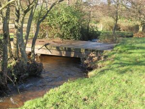
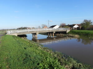
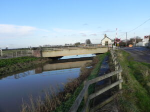
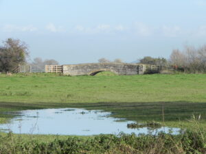
In 1901 Hugh P. Olivey wrote in his book “NORTH CURRY:ANCIENT MANOR AND HUNDRED” This substantial stone bridge remained until a few years ago when it was taken down by the commissioners of sewers. The road was then diverted and the river widened, the bank now occupying the position of the old road. The bridge was replaced by an inferior wooden structure.

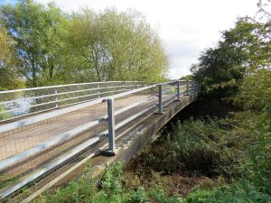
The actual date of the replacement was 1884 when the Drainage Commissioners undertook to maintain the newly built bridge.

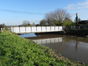
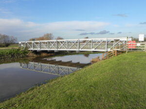
Jervoise states in 1930 that the bridge was a girder structure and that it was probably previously a timber bridge. He goes on to say ” At the Quarter Sessions, held in Wells in 1624, it was reported that Stanmore Bridge is greatly decayed and dangerous. The parishes concerned were ordered to repair or remake the bridge. In 1648 the bridge was again very much in decay, and rates were ordered to be paid for its repair. Four years later Ralph Frauncis, a carpenter, claimed payment for a repair to a ” certen woodden bridge called Stanmore Bridge”2

Whereas it appeareth by presentment that Stanmore Bridge is greatly decayed and dangerous for travellers, and whereas it likewise appeareth by an ancient order under the hands of Sir Nicholas Halswell and Robert CufTe, esq., and others, Commissioners of Sewers, that the said bridge ought to be repaired at the costs of the inhabitants of Aller, High Ham, Heywsh, Drayton, [ Curryrivell, Gregorystoake, North Curry, Taunton, Langport, and West Hatch : Ordered that the inhabitants of the said parishes shall repair or make new the said bridge before the 3rd may” and shall by that date collect pay such sums of money as be proportionately rated imposed upon=”upon” or at the next sessions show sufficient cause to (3)

It is known that Stanmoor bridge already existed in 1685. It would appear that the bridge was rebuilt in 1754 for a sum of £104. At a vestry meeting In 1780: “It being now reported to this meeting that Stanmoor Bridge a public Bridge lying in this Parish is now out of repair, and the same ought to be repaired by the Inhabitants of ten Parishes following, and by the proportions set against each of them, and that the sum of eight pounds is now necessary to be raised for the repair of the said Bridge. Resolved and ordered that Mr.Bendedict Barrington and Mr. Laurence Tuttiett the younger, Church Wardens of Gregory Stoke, do forthwith prepare a rate on the ten Parishes according to the proportions under named, and collect the same and apply.” (4)

     
References:   NORTH CURRY:ANCIENT MANOR AND HUNDRED by HUGH P. OLIVEY published in 1901
National Archives – (D\R\ta/23 – Case between R.D.C. and Stanmoor District Drainage Board D\R\ta/23/1 1865-1912)
2.The Ancient Bridges of the South of England by E.Jervoise published in 1930
3.GENERAL SESSIONS OF THE PEACE HELD AT WELLS the 11th, 12th, 13th, and 14th January, 22 James [1624-5]                                                                                                                      4. Stoke St.Gregory History Pages
5. Somerset Heritage Centre D/RA/2/9/23 Contracts, plans, etc., for bridges on the River Tone. 1889-1902 Includes Athelney Bridge, 1889-1890; Hook Bridge reconstruction of superstructure, 1901; Stanmoor bridge repair, 1893, and new steel bridge 1901-02; all in Stoke St. Gregory.

Athelney Bridge

Bridge Name:   Athelney Bridge
No.:   86
Location:   East Lyng – 51.05716,-2.93333
Build Date:    
Engineer:    
     
    Three span concrete structure.  The single carriageway deck supported on two piers of 3 concrete columns seated in the river. Metal parapet.  


Description:    
Athelney bridge, where the former turnpike crossed the Tone south-east of Athelney island, was a two-arched wooden structure in 1791. The present bridge is of concrete.

The Taunton-Wells road keeps to the crest of the ridge and forms the main route through the parish. Its course until the early 19th century, turnpiked by the Taunton trust from 1752 to 1875, passed through West and East Lyng and then ran along the Baltmoor wall south of Athelney Farm to cross the Tone at Athelney Bridge. A new road was built between 1803 and 1806 across Salt moor from the eastern end of East Lyng village direct to Burrowbridge. Improved alignment there involved a new tollgate in 1804-5 and a tollhouse c. 18051

A bridge here was subject to an enquiry held at Somerton in the year 1280, when it was pleaded that “the Abbat of Alingneye was bound to repair the bridge.”2

Jervoise states in 1930 that the bridge was a girder structure and was probably previously a timber bridge

The present Athelney bridge is of concrete, but the previous one, as recorded in 1791, was a two-arched wooden structure, where the former turnpike crossed the Tone south-east of Athelney island. The Taunton-Wells turnpike passed through West and East Lyng and then ran along the Baltmoor wall south of Athelney Farm to cross the Tone at Athelney Bridge. A new road was built between 1803 and 1806 across Salt moor from the eastern end of East Lyng village direct to Burrowbridge. (3)

     
References:   1. British History Online compid=18538
2. The Ancient Bridges of the South of England by E.Jervoise published in 1930

3. Stoke St.Gregory History Pages

Athelney Station Rail Bridge

Bridge Name:   Athelney Station Rail Bridge
No.:   85
Location:   51.05313,-2.93776
Build Date:    
Engineer:    


Description:   Steel underline bridge on reinforced concrete abutments
Carries the First Great Western line from London to Taunton. This section of the railway was opened in 1906 as part of a cut off between Castle Cary and Taunton to shorten the journey time fromk London to Penzance.
    Network Rail will be carrying out a variety of vital upgrades in Somerset, including track renewals at Witham Friary and Somerton Tunnel, signalling upgrades, and replacing a bridge over the River Tone at Athelney level crossing in Stoke St Gregory. Easter 2021
References:  

Hook Bridge

Bridge Name:   Hook Bridge
No.:   84
Location:   Near Curload    51.04570,-2.94708
Build Date:    
Engineer:    


Description:   Steel girder bridge. Replaced earlier wooden footbridge
 
     
References:  

New Bridge

Bridge Name:   New Bridge
No.:   83
Location:   Newbridge Hay Moor    51.03744,-2.97628
     
Engineer:    


Description:    
This is the site of the earlier Knapp Bridge.

“Considerable outlay is made on Knapp bridge. This seems to have been the principal point on the river for water carriage, and many entries will be found relating to this bridge. The importance of this can be readily understood from its being the most easily accessible spot on the river before the roads were made.” 2

Between 1678 and 1696 £35 was spent on repairs to the bridge including timber, iron, and raising the bridge ends2

In February 1766, the Conservators contracted John Robins of Langport, ‘within four months to take down the old Knapp Bridge, build over….the River Tone and erect a good and substantial new Bridge across the same river in the place and Head of the said old bridge now to be taken down. The new bridge to consist of one arch of one and twenty foot clear to be built entirely of good Pilsbury stone, except only the ringing which is to be built of Hamhill stone. Parapet walls 2 1/2ft high and 16 inches thick …..for his natural life and at his own proper charges provide and keep the piers and bridge from sinking.’

He was to be paid £45 for the entire work, £15 when the old bridge was taken down and the balance when the new bridge was complete. It is likely that poor Mr. Robins underestimated the cost of the work, for, on the 11 July, William Spiller ‘charged £45 for the supply of of the stone, lime and labour for Knapp Bridge’

This mention of Knapp Bridge is interesting, for there is little doubt that it refers to the bridge that preceded the present one at the point now called New Bridge near North Curry and was probably the reason for the name ‘New Bridge’. Pilsbury stone was specified by the Conservators as the main stone to be used; the quarries were situated between Langport and Long Sutton and being close to the River Yeo, the stone could easily be brought to the site by barge, using the River Parrett.1

The New Bridge sluice was built in 1938 and the old bridge demolished1

     
References:   1. By Waterway to Taunton -Tony Haskell
2. NORTH CURRY:ANCIENT MANOR AND HUNDRED by HUGH P. OLIVEY published in 1901

Knapp Bridge

Bridge Name:   Knapp Bridge
No.:   82
Location:   Knapp – 51.02947,-2.99718
Build Date:   Circa 1816
Engineer:   Possibly James Hollinsworth


Description:    
Road bridge. Single span, semi-circular arch, string course, end pilasters, hump backed bridge. Squared and coursed blue lias, saddle back Ham stone coping and Ham stone voussoirs.1

Replaced a timber bridge. For the new bridge they engaged the services of John Easton, a surveyor from Bradford on Tone, and the son of the well known surveyor, Josiah Easton. He was to work with his brother, William, from Hillfarrance, on erecting a new, single span, stone bridge, similar in design to the one built 60 years earlier at ‘New Bridge’. Pibsbury stone was again specified, but with two rings ‘in the arch in Hamden Hill stone’. For this work they were paid £380. Today, this elegant bridge still stands in splendid isolation on the moors, for the trackway is not used to the extent it once was. It is surprisingly good condition, considering the minimal maintenance it would have received over the intervening years, testimony to the high quality of craftsmanship that the Conservators brought to bear upon the work they undertook.2

The original Knapp Bridge was located downstream in the location of the current New Bridge

On the petition of the inhabitants of North Curry concerning a bridge in their parish called Knapp Bridge, which is very ruinous and likely to fall into utter decay without speedy prevention ; the Court orders that an assessment be made in the said parish as above [last entry], and appoints Giles Foster and Michael Potter, churchwardens of the parish, to be the collectors thereof.3

     
References:   1./www.tauntondeane.gov.uk/tdbcsites/her/her_lb/lbdets.asp?id=000005″>Taunton Deane B C
2. By Waterway to Taunton – Tony Haskell
3. Quarter Sessions 11 July, 23 Charles II. [1671.] Somerset Record Society v34
Also in The Ancient Bridges of the South of England by E.Jervoise published in 1930