Ham Bridge

Bridge Name:   Ham Bridge
No.:   80
Location:   Ham – 51.02152,-3.01977
Build Date:   2009 – 2010
Engineer:    


Description:    
Footbridge connecting Ham with Creech St Michael. There was a bridge at Ham before 1709. A new bridge at was built in 1758 but by 1839 it had been replaced by a bridge further east on the site of the present footbridge.

Following a bridge inspection in January 2008 Ham Bridge was condemned. Due to the length and location of the bridge it proved a challenge to find companies willing to quote for the removal of the current structure and the design and build of a new bridge. By the end of 2008, the old bridge was removed and within days the central pier had collapsed. In total, replacing the bridge with a 39 metre steel-framed, wooden deck structure cost around £90,000.

The bridge was officially reopened on 12th February 2010 by Cllr Anthony Trollope-Bellew, Cabinet member for Environment.

     
References:   /www.british-history.ac.uk/report.aspx?compid=18506″>British History Online

New Cut Bridge


Bridge Name:   New Cut Bridge 
No.:   79
Location:    51.02155,-3.03852 Creech St.Michael  Carries Lipe Lane
Build Date:   1960’s
Engineer:    
     
    After serious flooding in 1960 the river was deepened and widened, and New Cut was made south of Creech Bridge to carry excess water. (1)  


Description:    
 
     
References:   1. British History Online – https://www.british-history.ac.uk/vch/som/vol6/pp16-21

Tone Bridge Creech St Michael

Bridge Name:   Creech Old Bridge
No.:   78
Location:   Creech St Michael ST272255 – 51.02265,-3.03741
Build Date:   Medieval – Rebuilt 1700
Engineer:    


© Copyright somersetrivers.org

Description:    
Widened 1848 – Edward Murch, founder1
Three arches with iron railings instead of parapets caste on the railing girders is “Murock” 1848. In 1627 this was a timber bridge on stone piers The foolowing year the bridge is reported to be in ruinous decay and it is not known who should repair it.2Creech or Tone Bridge was repaired by the hundred of Andersfield in the 1620s. It was improved in 1830 and enlarged in 1848.3Petition from the inhabitants of Michael Creech that whereas not only the timber work of Creech bridge, which they are bound to repair, but also the arches or piers are become very ruinous ; and that they are burdened with the repairs of Ham bridge ; the Bench will order the bridge to be viewed and order other places to help in the charges. Endorsed : This bridge to be viewed before Bridgwater Sessions by Mr. John Colles, Will. Francis, Thomas Windham, Thomas Brereton, and Edward Rogers, esquires, or any three whether it be fit for the county to join in the repairing. John Harington.3Uppon the petition preferred unto the Court att the last Taunton Sessions by the Inhabitants of Creech shewinge that a certaine bridge called Creechbridge leading over the mayne river on the northside of the moore called Creechmoore, is fallen into greate decaye,the tymber worke of which bridge the Inhabitants of the parishe have ever mainteyned. But the arches thereof being Stoneworke ar very chargeable is now growen very ruinose and that it is not knownen by vvhome the said Stonevvorke hath or ought to be repaired. And for that the said Inhabitants of Creech are chargeable with the repayringe of other bridges, therefore desired the Court to consider thereof and graunt them some order for the repayringe of the said bridge. It was then desired by the Court and so ordered that Edward Rogers, JohnColles, Wittm ffraunceis, Thomas windham and Thomas Brereton,Esqsr., or any three of them would be pleased to examine the pmisses who of right ought to repaire the said stoneworke and whether it were fitt to lay the burthen thereof uppon the Country and to certifie their opinions therein att the Sessions then next followinge. Since which tyme little or nothinge hath ben therein done and that the said Mr. Rogers and Mr. Colles ar now dead. It is therefore at this present Sessions desired and so ordered that John Symes, Thomas Brereton, Willm ffraunceis and George Poulett, Esqrs., or any three of them wilbe pleased to examine the same accordinge to the first order and to certifie their opinions therein att the next Sessions att Bridgwater.4

A medieval County Bridge over the Tone at Creech St Michael was rebuilt as a three span masonry arch bridge in 1700. In 1848 this was widened on both sides by the addition of cast-iron road-plates and parapets supported on brackets built into the masonry spandrels, designed by Richard Carver, the County Surveyor. Edward Murch of Bridgwater supplied all the ironwork; his name is cast into the plates on each side. The two sides of the widening were tied together under the road construction by massive wrought-iron bars which were exposed to view when a reinforced concrete deck slab was installed in 2000. (5)

Renovated 2004 and reopened by MP Jackie Ballard

     
References:   1.Somerset Roads The Legacy of the Turnpikes Phase 1 – Western Somerset J B Bentley & B J Murless.
2.The Ancient Bridges of the South of England by Jervoise.
British History Online ref:18506
3.Quarter Sessions – Ilchester and Taunton Sessions,1627.
4. Quarter Sessions – Taunton 8th, 9th and l0th days of July, 4 Charles (1628),
5. Bridges Along the Tone – SCC Highways

Tone Aqueduct

Bridge Name:   Tone Aqueduct
No.:   76 A
Location:   51.02278,-3.04132
Build Date:   1835 – 1837
Engineer:   James Green or Sydney Hall


  © Copyright somersetrivers.org

Description:    
The Chard Canal ran from Creech St Michael to Chard, via Ilminster. James Green was appointed Engineer in 1831 but he was replaced by Sydney Hall before any substantial progress had been made. It is not known for certain which of them designed the aqueduct over the Tone near the Chard Canal’s junction with the B&TC at Creech St Michael, although the distinctive rounded cutwaters on the piers are similar to those that Green designed for many of his Devon bridges. The aqueduct has two 9m span brick arches and two 3.7m side spans; the piers and abutments are built of lias limestone, which was also used to face the elevations above springing level. Recent archaeological excavations revealed evidence that suggests the canal waterway was conveyed through a masonry trough, unlike the cast-iron troughs of the GWC aqueducts. The Chard Canal was finally opened in 1842, but railway competition soon took away its trade; it closed in 1868.
     
References:   Bridges Along the Tone – SCC Highways

Five Arch Bridge

Bridge Name:   Five Arch Bridge
No.:   76
Location:   Near Creech MILL – 51.02204,-3.04316
Build Date:   1863
Engineer:   Francis Fox


  © Copyright somersetrivers.org

Description:    
Disused railway bridge built of squared and irregularly coursed punched lias with Bath stone dressings. Five arch span bridge. Shallow arches, rusticated archivolts, piers resting on boat-shaped pontoons in river, raking abutments, regular projections above water level on the piers, broken off in some places, flat string course and flat coping, both of Bath stone. The outer arches of the bridge span the bank. The bridge carried the branch line of the Bristol and Exeter Railway Company to Chard. It closed in 1962. (1)

A branch railway from Taunton to Chard, running parallel with the Chard Canal, opened in 1866. Five Arch
Bridge carried the Chard Branch over the Tone 200 yards upstream of the canal aqueduct, until the line closed in
1962. The arches are built on a skew; the stone corbels on which the arch centering was supported can still be seen in each of the piers (2)


References:   1. www.tauntondeane.gov.uk/tdbcsites/her/her_lb/lbdets.asp?id=000227″>Taunton Deane B C  2. Bridges Along the Tone – SCC Highways

M5 River Tone Bridge

Bridge Name:   M5 River Tone Bridge
No.:   75
Location:   Taunton – 51.02301,-3.05784
Build Date:   1973 – 1975
Engineer:   Arthur Monk Ltd


Description:    
Three spans carrying the M5 motorway over the river. The bridge consists of two separate in-situ post-tensioned concrete box structures (one for each carriageway) with a curved soffit. The abutments are concrete cantilevers built on in-situ concrete piles.

Strengthened in 2001 to provide full capacity for 40 tonne lorries.

     
References:   Bridges along the River Tone by prepared by South West Regional members David Greenfield, Paul Nation, David Peake, Peter Radford and Paul Tucker.

Bathpool East Footbridge

Bridge Name:   Bathpool East  Footbridge
No.:   74
Location:   East of Bridgwater Road and a short distance downstream from Bathpool Bridge Taunton – 51.02596,-3.07030
Build Date:    
Engineer:    


Description:   Metal footbridge. Girders on concrete abutments. Metal parapet and wooden/metal slatted deck.
 
     
References:  

Bathpool New Cut Bridge

Bridge Name:   Bathpool Bridge
No.:   73
Location:   Taunton – 51.02595,-3.07073 – Carries the A38
Build Date:   circa 1836
Engineer:   Brunel’s assistant, William Gravatt


Description:   low-profile 22m span brick arch (24m on the skew) with grey sandstone facings and a a 7.6m span brick arch bridge over the towpath. Widened in 1930 and 2022
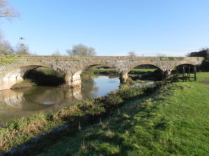
Jervoise in The Ancient Bridges of the South of England, published in 1930 writes:

“Two miles below Taunton the road to Bridgwater crosses the Tone at a village called Bathpool. Although the present bridge is relatively modern, the Bathpool Mills certainly existed in the fourteenth century. They were the property of the Abbott of Glastonbury, and were rebuilt, if not originally founded, by Abbot Walter de Monyngton about the year 1634. An Exemplification of December 15th 1384, recited an Inquisition taken at Taunton ( 6 Richard II.), when the jurors presented that ” tyhe said Abbot of Glastonbury maintains in Monkton trees overhanging the Tone right across it so that boats cannot pass as they were wont between the mill of Tobrigge and Bathpool….also that the highway between Taunton and Bathepole brigge is undermined owing to a new mill he had erected close to Bathpoolmulle.” “.In 1623 a petition was put forward to the Quarter Sessions which stated ” a certain stone bridge called the farther Bathe Pool bridge is now in great decay and very dangerous”. In 1653 the sum of £40 was raised for its repair. The present bridge is built of brick and stone, and was widened in 1927.”1

Upon a petition from the inhabitants of West Munckton that a certain stone bridge called the farther Bathe Poole Bridge is now in great decay for want of reparations, and very dangerous ; being a great thoroughfare way, the greatest in those parts, and must be repaired speedily ; and for that it is unknown whether it should be repaired by the County or some particular parishes or private persons : Referred to Sir Henry Hawley and John Symes, Thomas Brereton, Robert Cuffe and George Browne, esquires, or to any four of them, to take some speedy course for the levying of monies for the repairing of the said bridge, and to certify at the next Sessions what they have done in and about the said work.2

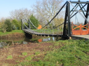
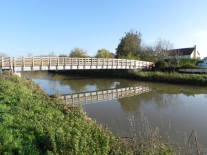
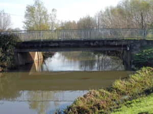
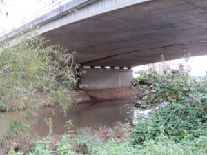
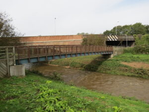
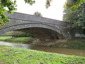
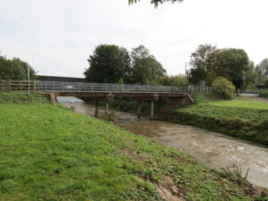
When the B&ER was being built in the early 1840s the meander at Bathpool was bypassed by diverting the Tone into a new channel (the “New Cut”) alongside the railway line, thus eliminating the need for two railway bridges over the river. Brunel’s assistant, William Gravatt, designed three arches to carry the Bridgwater road on a skew angle over the river , the towpath and the railway. Over the New Cut there was a low-profile 22m span brick arch (24m on the skew) with grey sandstone facings; next there was a 7.6m span brick arch bridge over the towpath, followed by a 9m span brick arch bridge over the railway. New Cut Bridge and the Towpath Bridge were lengthened on the west side when the railway and road were widened in the 1930s, and a steel girder bridge has
replaced Gravatt’s original Railway Bridge. 3


References:   1. The Ancient Bridges of the South of England – E.Jervoise – 1930
2. Quarter Sessions the 15th, 16th, 17th and 18th days of July, 21 James [1623],                   
3. Bridges Along the Tone – SCC Highways


Bathpool Accommodation Bridge

Bridge Name:   Bathpool Accommodation Bridge (ROW Footbridge No.4808)
No.:   72
Location:   West of Bridgwater Road Taunton  – 51.02594,-3.07163  Footpath T32/3
Build Date:   20th century
Engineer:    


Description:   reinforced concrete slab bridge with two supporting piers seated in the river. Metal parapet. Concrete deck.  Takes vehicles as well as pedestrians
 
     
References: