
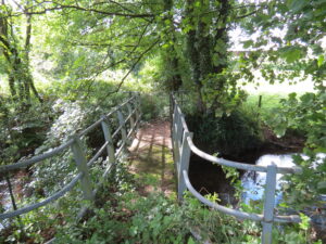
| Bridge Name: | Stawley Mill Footbridge | |||
| No.: | 25 A | |||
| Location: | 50.99303,-3.34458 | |||
| Build Date: | 20th Century | |||
| Engineer: | ||||
|
|
||||
| Description: | Wooden Construction | |||
| References: | ||||
| Bridge Name: | Stawley Mill Footbridge | |||
| No.: | 25 A | |||
| Location: | 50.99303,-3.34458 | |||
| Build Date: | 20th Century | |||
| Engineer: | ||||
|
|
||||
| Description: | Wooden Construction | |||
| References: | ||||

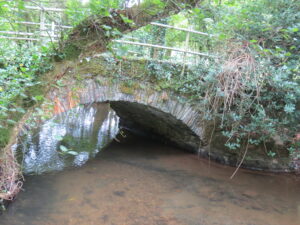
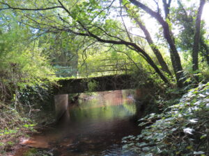
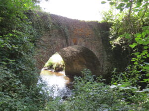
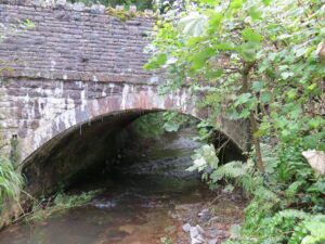
| Bridge Name: | Duckhams Bridge | |||
| No.: | 25 | |||
| Location: | 50.99317,-3.34478 | |||
| Build Date: | Rebuilt 1933 | |||
| Engineer: | Surveyor: Edward J. Stead | |||
|
|
||||
| Description: | Single Arch stone construction ( Stead concrete reconstruction?) | |||
| Boundry Stone on parapet SP AP 1856 – Marked the point on Duckham’s Bridge where the parish boundary between Stawley and Ashbrittle runs. Second plaque states reconstructed 1933 | ||||
| References: | Somerset HER No. 43895
SRO C/CA/31/5/1 Surveyor: Edward J. Stead, Weston-Super-Mare. Reference: 0504 Plan of Duckhams Bridge, Wellington Rural District. Oct 1932 |
|||
| Bridge Name: | Tuck’s Bridge | |||
| No.: | 24 | |||
| Location: | 50.99701,-3.34510 | |||
| Build Date: | ||||
| Engineer: | ||||
|
|
||||
| Description: | Single arch stone construction- Metal handrails | |||
| References: | ||||
| Bridge Name: | Hagley Bridge | |||
| No.: | 23 | |||
| Location: | 51.00603,-3.34711 | |||
| Build Date: | circa 1955? | |||
| Engineer: | ||||
|
|
||||
| Description: | Concrete deck on brick/stone abutments. Metal handrails | |||
| SRO C/CA/31/5/2 – Site plan and details. Surveyor: J.H.H.Wilkes, Taunton. Reference: 0506/01 | ||||
| References: | ||||
| Bridge Name: | Hagley Footbridge | |||
| No.: | 22 | |||
| Location: | 51.00609,-3.34709 | |||
| Build Date: | ||||
| Engineer: | ||||
|
|
||||
| Description: | Metal construction incl. hand rails. Solid infil to deck. | |||
| References: | ||||
| Bridge Name: | Castle Copse Footbridge | |||
| No.: | 21 | |||
| Location: | ||||
| Build Date: | ||||
| Engineer: | ||||
|
|
||||
| Description: | ||||
| Shown on ordnance survey map by the weir upstream from Pare Mill. This bridge does not exist. | ||||
| References: | ||||
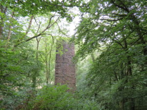
| Bridge Name: | Tone Viaduct Remains | |||
| No.: | 20 | |||
| Location: | 51.07511 3.210188 | |||
| Build Date: | circa 1870 | |||
| Engineer: | Brunel | |||
|
|
||||
| Description: | ||||
| Carried the GWR Barnstaple branch Closed by Beeching 1966 | ||||
| References: | ||||
| Bridge Name: | Pouch Bridge | |||
| No.: | 19 | |||
| Location: | 51.01422,-3.34975 | |||
| Build Date: | ||||
| Engineer: | ||||
|
|
||||
| Description: | Single arch stone construction | |||
| The bridge here was in need of repair in the year 1653, for in that year it was a matter for consideration at the Quarter Sessions1
Concrete plaque on bridge : SCC 1950 BIC – marks boundary between parishes of Chipstable and Bathealton and suggests work undertaken on bridge by SCC in 1950 |
||||
| References: | 1. Ancient Bridges of the South of England published in 1930 by E.Jervoise
2. Somerset Historic Environment Record 43910: Boundary stone, Pouch Bridge, Bathealton |
|||
| Bridge Name: | Waterrow Bridge | |||
| No.: | 18 | |||
| Location: | 51.02011,-3.35405 Carries B3227 | |||
| Build Date: | 19th Century | |||
| Engineer: | ||||
|
|
||||
| Description: | Single arch stone construction – | |||
| Known as Biballs Bridge before the construction of the turnpike road circa 1820. | ||||
| Eighteenth-century Turnpike road, Four Ways Cross to Wiveliscombe | ||||
| References: | SRO C/CA/31/79/1 Plan of Waterrow Bridge – Surveyor: Edward J. Stead, Weston-Super-Mare. Reference: 5340/01. Plan labelled: 9061/01
Somerset Historic Environment Record 43953: County bridge boundary Stone, E of Washbattle Mills, Washbattle, Wiveliscombe |
|||
| Bridge Name: | Pinkwood Cottage Footbridge | |||
| No.: | 17 | |||
| Location: | 51.02056,-3.35409 | |||
| Build Date: | ||||
| Engineer: | ||||
|
|
||||
| Description: | Wood construction | |||
| References: | ||||