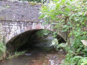
| Bridge Name: | Waterrow Bridge | |||
| No.: | 18 | |||
| Location: | 51.02011,-3.35405 Carries B3227 | |||
| Build Date: | 19th Century | |||
| Engineer: | ||||
|
|
||||
| Description: | Single arch stone construction – | |||
| Known as Biballs Bridge before the construction of the turnpike road circa 1820. | ||||
| Eighteenth-century Turnpike road, Four Ways Cross to Wiveliscombe | ||||
| References: | SRO C/CA/31/79/1 Plan of Waterrow Bridge – Surveyor: Edward J. Stead, Weston-Super-Mare. Reference: 5340/01. Plan labelled: 9061/01
Somerset Historic Environment Record 43953: County bridge boundary Stone, E of Washbattle Mills, Washbattle, Wiveliscombe |
|||