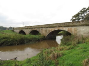
ridge Name: | Bradford Bridge | |||
No.: | 48 | |||
Location: | 51.00037,-3.18146 Oake Road | |||
Build Date: | Medieval Circa 15th Century | |||
Engineer: | Said to have been ‘built by the monks’, | |||
|
||||
Description: | ||||
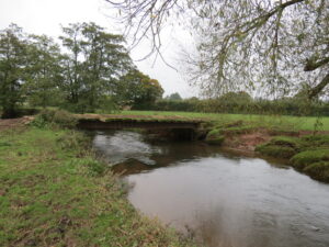
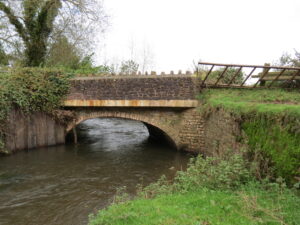
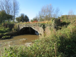
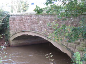
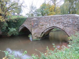
Road bridge built of random rubble local stone, ashlar dressings. Two arch span, 4-centred arches chamfered in 2 orders, soffits partly renewed in brick, central cutwater, string course, renewed parapet with chamfered coping. Said to bear date 1698 on parapet. Restored 1698, and late C19.
Road bridge over River Tone. C15, restored 1698, and late C19. Random rubble local stone, ashlar dressings, 2-arch span, 4-centred arches chamfered in 2 orders, soffits partly renewed in brick, central cutwater, string course, renewed parapet with chamfered coping. Said to bear date 1698 on parapet but not visible at time of survey (January 1985). Sheduled Ancient Monument (Somerset County No 104). (Photograph in NMR; Mathews, Bradford and its History, 1925). English Heritage Listed Building Number: 270946. First Listed on 25/01/1956.1 In 1617 the inhabitants of Bradford parish were liable to repair at least seven timber bridges and five stone bridges, including two major bridges over the Tone – one near the village and another 3 miles away at Hele, both of which were probably built in the 15th century. Bradford Bridge became a County Bridge before 1667. The Justices of the Peace also took responsibility for repairing 100 yards of each approach road, as was stipulated in the Bridges Act of 1530. On each approach to every Somerset County Bridge there was set up a stone inscribed “CBB”, which marked the “County Bridge Boundary”. By 1860 there were over 150 County Bridges, but only a handful of the boundary stones still survive, one of which stands on the west side of the entrance to the White |
||||
References: | /www.tauntondeane.gov.uk/tdbcsites/her/her_lb/lbdets.asp?id=001118″>Taunton Deane B C, The Ancient Bridges of the South of England by Jervoise. 1. Somerset HER 40892 3. Bridges Along the Tone – SCC Highways
|
Author: admin
Trefusis Farm ROW Footbridge No. 5165
Bridge Name: | Trefusis Farm ROW Footbridge No. 5165 | |||
No.: | 47 | |||
Location: | 50.99978,-3.18830 Footpath WG14/1 | |||
Build Date: | ||||
Engineer: | ||||
|
||||
Description: | Metal girders on concrete abutment. Wooden sleepers forn deck. | |||
References: |
Picking’s Bridge
Bridge Name: | Picking’s Bridge | |||
No.: | 46 | |||
Location: | 50.99756,-3.19777 | |||
Build Date: | circa 1844 | |||
Engineer: | William Gravatt | |||
|
||||
Description: | Single arch brick construction | |||
GWR Rail Bridge Bristol to Exeter Line | ||||
References: |
Ash Bridge
Bridge Name: | Ash Bridge | |||
No.: | 45 | |||
Location: | Near Ash Farm 50.99426,-3.20586 | |||
Build Date: | ||||
Engineer: | ||||
|
||||
Description: | Single arch stone construction. Widened and newly constructed stone parapet. | |||
References: |
Grand Western Canal Viaduct ROW No.5132
Bridge Name: | Grand Western Canal Viaduct ROW No.5132 | |||
No.: | 44 | |||
Location: | 50.99417,-3.21690 Footpath WG8/5 | |||
Build Date: | 1828 | |||
Engineer: | James Green | |||
|
||||
Description: | ||||
Footpath across the Tone using the old Aqueduct that once carried the Grand Western Canal across the River Tone
Aqueduct carrying the Grand Western Canal (PRN 44126) over the River Tone The stone work of the wide, graceful arch of this slender 30ft span structure is in good condition and, although the parapet is crumbling, it can still be crossed, when the iron trough which contained the water will be seen. The aqueduct is skewed to avoid scour of the abutments and wing walls. The skewed horizontal iron waterway trough spans a little over 9m between the abutments and was made in the form of a flat arch in three sections with splayed joints similar to stone voussoirs. It is restrained in a longitudinal direction by inclined iron brackets at the junction of the three sections of the trough. The brackets protrude into the masonry at each side.1 |
||||
References: | 1. Somerset HER 44140 |
Hornshay Bridge
Bridge Name: | Hornshay Bridge | |||
No.: | 43 | |||
Location: | 50.99418,-3.22340 Carries Nynehead Road | |||
Build Date: | Current Bridge: 1912 | |||
Engineer: | Designed by Edward Stead, when he was Assistant County Surveyor | |||
|
||||
Description: | ||||
Among disbursements for 1668, mention is made of repairs to County Bridges, Hornshay2
The parish of Nynehead was for many years responsible for the repair of the bridge; the churchwarden’s accounts of this exist from C16. The maintenance was taken over by the new Milverton Highways Board in the 1860s. In 1876 a notice was erected at the approaches stating ‘This bridge is only of sufficient strength to bear the weight of ordinary traffic. Persons causing steam locomotives and traction engines to pass over it will be held responsible for any damage done thereby’ The present bridge was built in 1912. When the old bridge was demolished it was found to be supported by oak piles. Reinforced concrete arch bridge built in 1912 and designed by Edward Stead, when he was Assistant County Surveyor. Copings, stringcourses and quoins are of ashlar masonry with the remainder of the masonry rock faced. The end of the concrete deck is exposed in elevation. The bridge is 26 feet in span.1 In 1594 an old stone bridge that carried the West Buckland to Nynehead road over the Tone was known as Langhams or Longham Bridge, and later as Hornes Hay Bridge. An ancient legal responsibility made Nynehead parish liable to repair the northern half of the bridge, Wellington parish two-thirds of the southern half of the bridge, and West Buckland parish the remainder. The liabilities were in force until the 1860s, when responsibility passed to the Milverton Highway Board and then to the County of Somerset. It was rebuilt in 1912 as a reinforced concrete arch bridge, and was one of the earliest of over 60 concrete bridges that were constructed in Somerset between 1909 and 1930 to the design of Edward Stead, who retired as County Surveyor in 1946..3 |
||||
References: | 1. Somerset HER 19901 2. An Early Portion of the Church Warden’s accounts of All Saints, Nynehead (1668- 1684).BY W. DE C. PRIDEAUX, L.D.S. ENG., F.R.S.M. 3. Bridges Along the Tone – S.C.C Highways4. Somerset Records Office – C/CA/31/8/1 Plan of Hornshay Bridge Rebuilding, Wellington Rural and Urban District Councils. 12 Sep 1912 |
Hornshay Weir Footbridge
Bridge Name: | Hornshay Weir Footbridge | |||
No.: | 42 A | |||
Location: | 50.99391,-3.22451 just upstream from Hornshay Bridge | |||
Build Date: | 19th century | |||
Engineer: | ||||
|
||||
Description: | Prefabricated iron construction | |||
Weir was used to power a waterwheel and later turbine to provide electricity to Hornshay farm. | ||||
References: |
Nynehead House ROW Bridge No. 5134
Bridge Name: | Nynehead House ROW Bridge No. 5134 | |||
No.: | 42 | |||
Location: | 50.99413,-3.23004 Footpath WG8/19 | |||
Build Date: | 1817 | |||
Engineer: | Thomas Lee | |||
|
||||
Description: | ||||
Former road bridge over River Tone on drive to Nynehead Court (qv), now disused. Dated 1817. By Thomas Lee for W A Sandford. Brick faced with grey Knapp sandstone, ashlar coursed with V joints giving strong vertical emphasis, voussoirs, strongly moulded string course, parapet of large dressed blocks rising from string course with chamfered tops. Plan: 3 arch span, shallow elliptical arches, cutwaters both sides but mostly submerged in mud, square piers abutting, topped with small square plinths that probably carried some sculptural decoration when erected. Soffit of central arch with inserted York stone slab inscribed “W A Sandford 1817”, soffit of south arch plain, north not visible from bank. North-west pier damaged, north-east pier obscured by ivy at time of survey (February 1985), string course damaged in places and obscured by ivy, fissure in south-west abutment. A fine design that was exhibited at the Royal Acadaemy in 1818. (Colvin, Biographical Dictionary of British Architects, 1978). English Heritage Listed Building Number: 271006. First Listed on 25/01/1956.1 | ||||
References: | 1. Somerset HER 40957 |
Tone New Bridge
Bridge Name: | Tone New Bridge | |||
No.: | 41 A | |||
Location: | Tonedale – 50.99009,-3.24652 Carries the B3187 | |||
Build Date: | circa 1972 | |||
Engineer: | ||||
|
||||
Description: | Concrete beam bridge with metal parapet | |||
Somerset Heritage Centre C/CA/31/222/36 Plan of Tone Bridge, Wellington. Oct 1972 Details of siteworks. Scale 1:100. Surveyor: A.S.Turner, Taunton. Reference: 8552/a/04 | ||||
References: |
Tone Bridge
Bridge Name: | Tone Bridge | |||
No.: | 41 | |||
Location: | Tonedale 50.98978,-3.24647 | |||
Build Date: | ||||
Engineer: | ||||
|
||||
Description: | Two arch stone and brick construction | |||
Rebuilt for 1914 for £146 by George Pollard and Sons. On the route of the Milverton to Tone Bridge turnpike, operated by the Wiveliscombe Trust1 | ||||
References: | 1. Somerset Roads The Legacy of the Turnpikes Phase 1 – Western Somerset J B Bentley & B J Murless. |